sitemap
R e s e a r c h 
" C l o u d   c i g a r "   o v e r   S a i n t - P r o u a n t ,   F r a n c e
Martin SHOUGH & Wim VAN UTRECHT
 Possible explanation

2.1. Tornado funnel?

Aimé MICHEL noted early suggestions that the phenomenon could be explained as what he calls (in the original French) a "cyclone", or tornado funnel (see for example Fig. 3). But he found it incredible that the Vendéan peasants would have been unable to recognize a tornado, mistaking it for a flying saucer, and objected that a stationary tornado remaining in one position under racing clouds for the best part of half an hour, turning to a horizontal position, and releasing a bright metallic disc, "would fascinate meteorologists". Moreover he pointed out that "il n'y a pas eu de cyclone dans cette région le 14 septembre 1954, ni nulle part en France" - there was no cyclone in this area or elsewhere in France on September 14, 1954.

One of the present authors has suggested elsewhere [4] that MICHEL may have been confused about the meaning of the term "cyclone". While a tornado is a localized, rotating column of air emerging from the base of a cumulonimbus cloud, the term "cyclone" is widely used to indicate a much larger area of low atmospheric pressure characterized by inward spiralling winds. It is possible that MICHEL's sources were referring to this latter type of cyclonic weather. But on the other hand, if MICHEL wrote "cyclone" he was in fact strictly correct. A tornado is a cyclone, and a funnel cloud is a cyclone, although neither a cyclone nor a funnel cloud is necessarily a tornado [5].

Spectacular funnel near Denver, Colorado

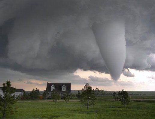
Fig. 3: Spectacular funnel near Denver, Colorado, June 2009 - more info about this photo at VO-FU-08. [Photo: Darrel Watson. From The Denver Post.]

2.2. Occurrence of tornadoes in France

It appears to be true that there is no record in any available list of a French tornado on September 14, 1954.

Although on average about 8 tornadoes are reported per year in France according to DESSENS & SNOW [6], the only French tornado listed in their catalogue for that year (#47) is an F3 on the Fujita tornado damage scale touching down at 1330 UTC on August 14 in Noirétable, a village very far from St-Prouant, about 80 km (50 miles) West of Lyon in south-central France (see also [7]). The only other findable West European tornado of record in 1954 is the Castelo Branco, Portugal, F3 on November 6. However there could have been others, especially if they were relatively weak. And many funnel clouds that do not become true tornadoes would probably be excluded altogether from these statistics.

Although most accounts say that tornadoes develop from mesocyclones in thunderstorm supercells that do signify intense, cyclonic low pressure systems, there are other mechanisms associated with wind shear along weather fronts which can cause funnel clouds. These are known as cold-air funnel clouds, or cold-core funnels. It's important to note that these funnels lack many of the more dramatic features of mature tornadoes that are generated by uplift of warm, moist, low-level circulation into a storm cell mesocyclone. They are much weaker than the classic tornados spawned in this way, but could fit the recorded weather of September 14, 1954. And an immature funnel cloud that never developed to a touch-down would not have generated a catalogue record of a true tornado.

According to a study of the new European Severe Weather Database [8] the records from 1950-2000 were patchy and are not yet fully included. But Table 1 shows that annual reporting of funnel clouds increases dramatically by a factor 27 during the first nine years of the database from <10 to >260, in the order of 10 times the increase in reporting of tornadoes during the same period, which suggests, extrapolated into the past, that there would have been very significant under-reporting of European funnel clouds in the mid-20th century.

Frequency of reported European severe weather events 2000-2008

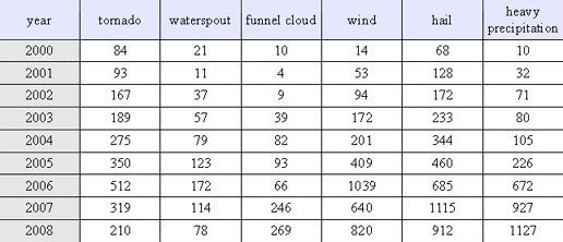
Table 1: Frequency of reported European severe weather events 2000-2008 (after DOTZEK et al., 2009).

Most French tornadoes occur in the NW quadrant of the country, clustering nearer to the coast in winter, and it appears that Saint-Prouant may lie close to a tornado corridor or "alley". See the map in Fig. 4 showing 107 French tornadoes recorded over about two centuries, whose distribution appears not dissimilar to that of 471 tornado and funnel clouds recorded for the recent period Jan 1988-Dec 2010 in Fig. 5.

Distribution of French tornadoes

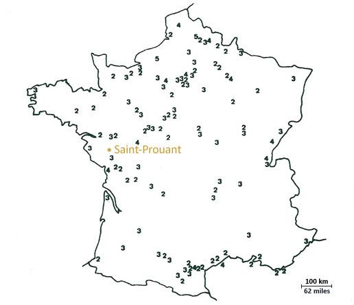
Fig. 4: Distribution of 107 French tornadoes between 1680 and 1987 with their F-numbers. [Adapted from DESSENS & SNOW, 1989.] See also Fig. 5.

French tornado and funnel reports 1988-2010

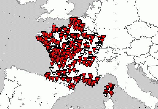
Fig. 5: All French tornado and funnel reports in the European Severe Weather Database for the years 1988-2010 inclusive (n = 471). Tornadoes are red, funnel clouds are white. Saint-Prouant appears to lie close to a wedge of tornado sites extending inland from the Atlantic coast of France where the density of overlapping symbols is evidently greatest. [www.essl.org; see also DOTZEK, et al. 2009. [9]]

Statistically, tornado development strongly favours the late afternoon hours between 16:00 and 18:00hr local, matching the distribution of thunderstorm development due to atmospheric heating. This notable association has been called "5 o'clock magic". Whether this pattern is followed to the same extent by weaker funnel clouds caused by weather types other than mesocyclonic storm development is uncertain. The occurrence of the St-Prouant phenomenon at 5 o'clock local time is nonetheless an interesting coincidence.

2.3. The weather pattern on September 14, 1954

The eyewitness reports from St-Prouant describe what does sound like the onset of stormy or at least blustery weather - "a thick layer of clouds that looked like a storm coming up", "clouds where the storm went up", and "dark clouds" that were "scudding" across the sky "very fast". But in this case there seems to be no chance whatever of a classical tornado spawned by an intense stormy depression. Synoptic surface pressure charts for September 14, 1954 (Figures 6a and b) in fact show high pressure in control over most of Europe south of Scandinavia, and French weather stations (e.g. Bordeaux [10] and Orly [11]) confirm elevated pressure.

sea level pressure and heights of 500 hPa pressure level 0000 GMT

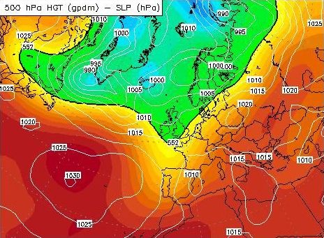
Fig. 6a: Sept 14, 1954, 0000 GMT - sea level pressure and heights of 500 hPa pressure level. www.wetterzentrale.de]

sea level pressure and heights of 500 hPa pressure level 1200 GMT

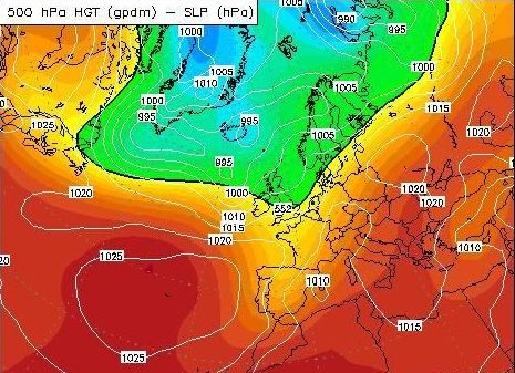
Fig. 6b: Sept 14, 1954, 1200 GMT - sea level pressure and heights of 500 hPa pressure level. [© www.wetterzentrale.de/]

relative humidity at 700 hPa pressure level 0000 GMT

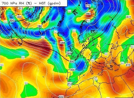
Fig. 7a: Sept 14, 1954, 0000 Z - relative humidity at 700 hPa pressure level.
[© www.wetterzentrale.de/]

relative humidity at 700 hPa pressure level 1200 GMT

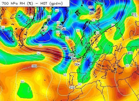
Fig. 7b: Sept 14, 1954, 1200 Z - relative humidity at 700 hPa pressure level.
[© www.wetterzentrale.de/]

relative humidity at 700 hPa pressure level

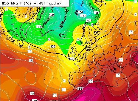
Fig. 8a: Sept 14, 1954, 0000 Z - relative humidity at 700 hPa pressure level.
[© www.wetterzentrale.de/]

relative humidity at 500 hPa pressure level

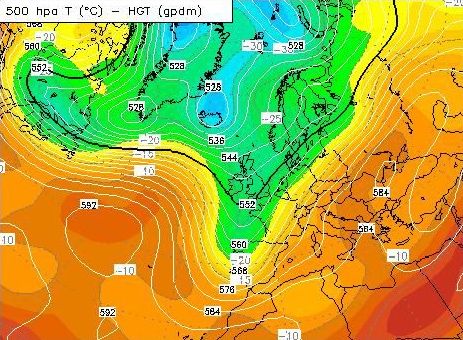
Fig. 8b: Sept 14, 1954, 0000 Z - temperature at 500 hPa pressure level.
[© www.wetterzentrale.de/]

temperature at 850 hPa pressure level

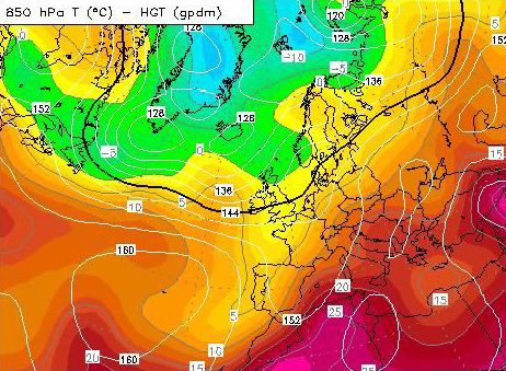
Fig. 9a: Sept 14, 1954, 1200 Z - temperature at 850 hPa pressure level.
[© www.wetterzentrale.de/]

temperature at 500 hPa pressure level

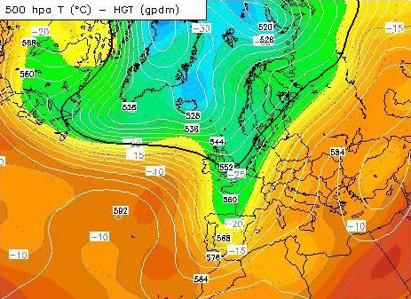
Fig. 9b: Sept 14, 1954, 1200 Z - temperature at 500 hPa pressure level.
[© www.wetterzentrale.de/]

The pressure maps show the likelihood of strong, moist westerly winds being channelled along squeezed Atlantic isobars between an approaching high pressure centre off Portugal and a low pressure centre to the Northwest of the British Isles. The Monthly Weather Review for September 1954 summarises the dominant northern hemisphere circulation pattern as follows:

Over the British Isles and adjacent sections of Europe 700-mb. height anomalies were negative once again in September as they have been during the entire summer.. However, the negative anomaly center was stronger than it had been in any of the summer months and was almost 10° of latitude farther north than its position in August. Meanwhile heights were well above normal in the Azores High and over the Mediterranean. Thus, westerly flow at middle latitudes over the eastern Atlantic and western Europe was as much as 9 m/sec stronger than normal. At 700 mb. the strongest winds in the Northern Hemisphere were located near latitude 50° and longitude 20° W. The axis of this pronounced jet stream at both 700 mb. and 200 mb. crossed southern Britain and the North Sea. As a result, the weather in the British Isles and adjacent areas of northwestern Europe during September was cool with frequent storminess and many frontal passages [12].

These westerly jet winds off the Atlantic coast of France averaged 16 m/sec or 31 kt through the month at 700 mb. At 200 mb they averaged 20-30 m/sec (39-58 kt).

If we can put together a picture from these charts and figures then we see the possibility of strong westerly winds from the sea following the squeezed Atlantic isobars (Fig. 6), and warm surface air flowing northwards from the Mediterranean being forced under an elevated tongue of drier (Fig. 7) and colder (Figs. 8 and 9) air extending south from the UK over Northern France at the 500-700 mbar (hPa) level. This picture resembles the special conditions for one of the two basic models of French tornadogenesis.

One of these two models is generally speaking a Summer model, characterised by a weak low in the surface field over France and typically a deep 500 hPa low over the Bay of Biscay or west thereof with inflow of warm Mediterranean air from the south. This does not resemble the type of situation we see on September 14, 1954.

But in the Winter model a low level intrusion of warm air from a Mediterranean high pushes north across France whilst trapped under a dry capping layer, advected from under the cap to meet strong westerlies off the Atlantic entrained by deep low pressure in both height and surface fields centred to the NW of the British Isles. Moist warm air forced under the colder Atlantic airstream creates great conditional instability which may be triggered by local effects within the warm air mass. [13]

This picture seems very similar indeed to the synoptic situation on September 14, 1954 (which would statistically be on the borderline between Winter and Summer regimes). In summary the weather pattern seems consistent with one of the patterns tending to favour the development of funnel clouds.

 Notes & references

[4] VAN UTRECHT's earlier article on the case published on this site, but now replaced by this paper.

[5] The nomenclature is confusing. A cyclone is any type of anti-clockwise atmospheric circulation (in the Northern hemisphere; clockwise in the South). It may be a large area of slightly lowered pressure such as we are used to seeing on synoptic weather charts, or it may be an intense vortex of low pressure on a variety of scales. A tropical cyclone is an intense synoptic-scale vortex otherwise known as a hurricane. A small violently rotating column of air only a few hundred metres across is a microscale cyclone often associated with a funnel cloud, which might become a tornado (or waterspout on the sea) but only if it reaches the surface. If the cyclone does not touch down it remains a funnel cloud. A microscale cyclone that becomes a funnel cloud and/or a tornado is usually born from a mesoscale cyclone (or mesocyclone) in storm cloud.

We cannot comment on French popular usage in 1958 but it is possible that MICHEL may have written his French manuscript with an American readership (and an American translator, Lex Mebane of CSI NY) in mind. According to the English-language Wikipedia: 'a tornado (...) is also sometimes referred to by the old-fashioned colloquial term cyclone. The term "cyclone" is used as a synonym for "tornado" in the often-aired 1939 film, The Wizard of Oz. We note that basement shelters built under houses in tornado prone areas of the US have often been known as "cyclone cellars".

Howsoever the English edition (Flying Saucers & The Straight Line Mystery, Criterion, 1958, p. 26) translated by MEBANE does have "cyclone" rendered as "tornado":

"The only other conventional explanation that might possibly suggest itself is that what the Vendée farmers saw was the conical funnel-cloud of a tornado or waterspout. As it happens the meteorologists are definite on that point: there was no tornado anywhere in France on September 14".

In our opinion it is not certain that MICHEL was misunderstanding the terminology. Meteorological records (see weather charts on this page) do show that there was indeed no synoptic-scale cyclone over France that day, but MICHEL's meteorologists could equally well have been talking about tornadoes.

[6] DESSENS, J. & SNOW, John T., "Tornadoes in France", Weather & Forecasting, Vol. 4, 1989, pp. 110-132 - journals.ametsoc.org.

[7] en.wikipedia.org

[8] Ibid.

[9] DOTZEK, Nikolai et al., "Overview of ESSL's severe convective storms research using the European Severe Weather Database ESWD", Atmospheric Research, Vol. 93, Issues 1-3, July 2009, pp. 575-586, Proceedings of the 4th European Conference on Severe Storms - 4ECSS, elib.dlr.de/.../dotz.pdf.

[10] www.tutiempo.net (Bordeaux_Merignac)

[11] www.tutiempo.net (Paris-Orly)

[12] WINSTON, J.S., "The Weather and Circulation of September 1954", Monthly Weather Review, U. S. Weather Bureau, Washington, DC, p. 261.

[13] DESSENS, J. & SNOW, John T., "Tornadoes in France", Weather & Forecastingg, Vol. 4, 1989, pp. 110-132 - journals.ametsoc.org.